


tour
of East Turkey
day ½ - June
4 - Happy Wanderers Reunite
It's 5 p.m. and time for our Eastern Turkey group to meet in the banquet room of the Hotel Ickale. Most of us have either traveled to Turkey on the first trip together, or we met our travel buddies the previous night in the hotel lobby. All of us are alumni's of Lale's and Tan's Western Turkey tours. It's great to be among old friends. After a warm welcome, Lale introduced us to her former archeology professor, Dogu Mermerci. He will be conducting an educational tour to an ancient Hittite village tomorrow. We are to address him as hocam, (ho jum-"my teacher"). Tankut poured us all a glass of wine while Lale talked about the itinerary. We raised our glasses to toast to renewed friendships, new friendships and an adventuresome trip.
At 7 p.m. we adjourned to the hotel restaurant where we had an outstanding dinner of salad, stuffed squash, bulgur in spicy red sauce, lamb stew and a house specialty of honey pastries...
day 1 - June 5 - Ankara to Amasya - Hittite Empire - Lynne Curry
Today is much cooler as we tearfully wave good-bye to our dear friend Mary Ann, who must leave us to guide a tour in Europe. Our destination is Hattusas, site of the ancient Hittite capital called Bogazkale. We drove along for a couple of hours through lush green farmland, passing over the Red River (Kizilirmak) that flows through Turkey into the Black Sea. Along the way, our esteemed professor explains the history of the ancient Hittites and describes the first use of cuneiform tablets. The first types of written communication on stone tables were invented by the Syrians during the Bronze age.Tankut took the microphone and proceeded to tell us about the Turkish economy.
We reached Bogazkale around 10 a.m. From the bus one could look up the green hillside to the rock foundations of some 30 temples built by the Hittites. Our first hillside stop was at the Lion's gate-the main gate used by kings. You could still clearly see the grooves in the rock walls that were carved to allow the wheels of chariots to pass through. Inside the gate are remains of two large stone lions on each side of the gate. They stand ready to protect the city. The gates were built of wood and plated in bronze to protect them from burning by invaders. Today, local villagers display their hand carved stone lions, gods and jewelry for sale.
This Hittite city was surrounded by two defensive walls. The exterior wall guarded against outside invaders, while the interior wall protected the palaces. Further up the hill, we stop at the Tunnel Gate. This massive 220 ft triangular tunnel extends through the defensive wall, slopping downward into the city. The professor points out the tight fit of the hand chiseled blocks on the retaining wall. Walking along the top of the wall, we came to the Sphinx Gate, named for the 4 Sphinxes carved into the corners.
We asked hocam what was the population of Bogazkale at its most prominent time. He told us that it was not possible to estimate the population. The guidebook that most of us bought says there was no record of the population in any known documents. Also the uneven terrain, the distribution of the city on artificial terraces and the presence of large temple areas in the upper and flower city make even an estimate impractical. The area had been settled during Paleolithic times, although evidence shows Bogazkale was occupied around the second or third phase of the Early Bronze period.
Back on the bus, we drive about 500 yards past the Kings Gate. We proceed downhill to the Great Palace, the most intact of the ruins. The site was also a library for 10,000 cuneiforms. Hocam pointed out the cisterns, storage areas, and river below called Deep Throat. In front of the Great Palace stands a large cuneiform rock tablet with Arabic hieroglyphics proclaiming the king's deeds. Rocks used to build the palace come from a quarry just behind the city gate.
It's early afternoon, so we stopped at a small town of Asikoglu for lunch. Tankut gave us the green light to try as many dishes as we like in this cafeteria-style restaurant. The food was delicious. Refueled, we were back on the bus headed for the Open Air Sanctuary (Yazilikaya).
The roofless, rock cut, triangular sanctuary contains three rooms. Each has carvings of famous deities of the Hittite period. Hocam names the Hurrian name of each of the 63 gods. The first 14 are Mountain Gods. Next are sun, moon, weather gods, 2 maidens of Goddess Ishmar, war gods, water gods, etc. The great King relief is that of King Tudhaliya. The sanctuary is the sacred place that priests may bring the ash remains of former kings.
We left the Open Air Sanctuary and drove 16 km to the summer palace of the Pontic Kings. This palace was built in honor of the sun goddess Arinna. Dogu did some excavating at this site in the 1970's. He proudly points out the stones he researched and identified.
It is late afternoon now, our head numb with fascinating details. Dogu bids us adieu. Our thoughtful Texans, Alicia and Tyrrel, presented the professor with a card and Texas flag in appreciation of his time and expertise shared with us. Dogu was very touched by this show of appreciation.
In Amasya, the group split up-one group stayed in a small pension, the other in town at a small hotel. Dinner was a lovely home cooked meal in the cool garden at the pension. Our hosts are both pharmacists and have a lovely, young daughter who speaks English quite well. Tired and full, we're off to bed for a goodnight's sleep.
day 2 - June 6 - Amasya - Sue Larsen
Our first day in Amasya starts leisurely with a late breakfast. Tankut and Lale then lead a group walk through the town of Amasya to show highlights of the town and preview it's historic past. The first stop is the Gök Medrese Camii (1266) and the Tomb of Torumtay (1255 - 1320) where the group gets a brief summary of the history of Amasya and the Black Sea Region of Anatolia.
From the Bronze Age onward Hittites, Assyrians, and Phrygians inhabited this area. In the 3rd Century BC. Amasya became the capitol of the Pontic Kingdom and dominated most of Anatolia. Amasya was the birthplace of the historian Strabo (circa 63 BC). In 47 BC, the Romans invaded the area and during their occupation Amasya was a major garrison town. Following the Romans were the Byzantines then the proto or Seljuk Turks in 1174 AD. Islam became the primary religion as a result of this last invasion and has remained so to the current day.
The Mongolian invasion in the 13th Century resulted in the decentralization or fragmentation of the Anatolian Empire. The 14th Century marks the foundation of the Ottoman Empire finalized by the fall of Constantinople to Sultan Mehmet II in 1453. The end of the Byzantine Empire marks the end of the Middle Ages and the beginning of the Renaissance.
Under the Ottomans, Amasya became the city of the Crown Princes, with the candidates to the throne being sent to this area for their training. Varying reasons for the decline of the Ottoman Empire were discussed, one being the process (s) for the selection of the successor to the throne. As these processes changed under political pressures of the time, instability and internecine struggle became the order of the day. On June 12, 1919, Mustafa Kemal (Ataturk) organized a meeting at Amasya to signal the start of the War for Independence. Amasya still celebrates that date. At the onset of the Republic, approximately 95% of Turks were illiterate.
Ataturk banned the Madressahs, which were the schools for religious studies and education became secularized. At that time, the Gök Medrese Camii was converted to a museum. The eyvan serving as its main portal is unique to Anatolian architecture. It is known as the Sky Madressah Mosque due to the turquoise and blue tiles found on the exterior. Today it is actively used.
Next we proceed to Amasya's primary mosque, that of Sultan Beyazit II, dated 1485. The mosque complex incorporates a library, medressah, kitchens and garden areas. Tankut describes the transition of mosque architecture from the madressah to the classical "Kulleyi" construction as seen in the Sultan Beyazit II Camii. The group is able to meet the muezzin who explained the calligraphy found in the interior of the mosque. Tankut next takes us to an old madressah to show an example of the early evolution of a caravanserai to madressah (14th-15th C.) to a now functioning workshop. Much of the original brickwork is still evident.
Just adjacent to the workshop Tankut points out a fine example of late Seljuk masonry in the Burmly Minare Camii (1237), currently an active mosque. This same stop gives us our first photo op of the Pontic tombs and Citadel which overlook Amasya from the opposite side of the river. The tour ends for the day with suggestions for further activities.
Several of the group cross the Yesil River and proceed to the Pontic tombs, which were built prior to the 11th Century BC. These 5 Kings Graves are carved from the sheer rock face high in the cliffs overlooking the city. The lower of the tombs, one being the "Mirror Cave" Aynali Magara, was a pleasant walk up sculpted steps in the rock face. A marvelous rock cut cleft passage gives easy access between the two tombs. We paused to appreciate the view of the distant city and take photos. As we are intrepid travelers, we head towards the remaining three tombs. We soon discovered that only a rocky goat trail serviced the tombs, which were much higher in the cliffs. After much grunting, pushing, pulling and generally sweaty athletic exertion we were rewarded with another spectacular view. What made the view even more breathtaking was there were neither guardrails nor safety devices whatsoever between the tourist (us) and the natural environment (valley floor).
We return to the pension for a tasteful dinner served by our hosts. Some finished the evening with a walk around town and to view some of the historic homes across the Yesil River. The Hatuniye Mahallesi area parallels the river and contains many old restored homes. Many are private residences and some are being converted to pensions or bathhouses.
day 3 - June 7 - Sarah Hill
The group was up early heading out for a most unique day. After our fascinating start out in Hittite country, we were ready for more. We headed out southwest from Amasya through beautiful, lush green countryside with lovely wildflowers and unusual, purple poppies.
On we drove through Tokat and Sivas. Many of the attendants in hamams come from these two towns. By noon we had arrived at a small side road northeast of Sivas where our guide from the remote village met our big bus. We were to be their very first American visitors and the whole village turned out to welcome us.
Our first impressions were of a very rustic village made of stone and mud houses with all these smiling faces greeting us. They had to move some rocks out of the road for us to finally park the bus where there was enough space. The dirt road was very narrow for "Big Yellow." Raffet saved the day.
We were immediately surrounded by most of the men in the village. We were to shake hands with each one and happily greeted them all with our very best "Merhaba's." The woman and children were not far behind. We could not have received a warmer welcome.
Immediately, the 13 ladies in our group were ushered up to the biggest, nicest house in town to use the "tuvalet." This house was only 2 years old and had been built for the parents of a son who had made money in Germany and provided very handsomely for his family. Gullu and Mustapha were very proud to have us sit and wait our turns in their newly furnished "parlor." The modern "tuvalet" was temperamental but Gullu aided our cause with extra buckets of water. After a complete tour of the house and its kitchen with marble counters, hardwood floors and beautiful wrought iron work and ceramic tile floors in the entrance hall, we were ready for their banquet.
Down the hill we all walked, accompanied by the village women who were eager to walk arm-in-arm with their new friends. Most of the women had their heads covered, wore traditional baggy pants and sweaters with a vest over it. A few had a gold necklace-again maybe a gift from a working son.
The men were already gathered by the very long table set up in the grass. They had real plates and silverware and flowers on the table. The villagers had all worked on preparing the food for us and we were very impressed to see they had slow-roasted two lambs in a pit. They were served whole on huge round trays. They just tear away pieces to serve you. The villagers enjoyed it as much as we did. They had also prepared huge pilavs for us-Lale says they cooked 5 kilos of rice. Their pilav was really delicious flavored with bits if liver, pine nuts & currants- mmmm. We also had the usual tomato-cucumber salad -so finely chopped it must have taken a whole day to prepare. They also served bowls of bulgur wheat with what seemed to be tomato sauce mixed in. They had diluted 4 kilos of yogurt to make our ayran to drink. We loved sitting in this beautiful place surrounded by the warmth of our new friends. The feelings were mutual.
After this remarkable feast we went to see where and how they make their bread for the village. It is in a stone house that is about 100 years old with a unique wooden roof that has a smoke hole in the top. Dough of flour, water and oil is mixed by hand and shaped into round balls a little bigger than a tennis ball. These are placed in a big pan like a dishpan. They have a wood fire that makes their oven, which is a convex round plate called a "sac." They flatten each ball and quickly bake their thin bread on this hot plate. It is turned with a flat stick called an "oklava" and the finished product is called "gozleme." This bread is often folded around filling of meat, potatoes or cheese or any combination of this and is called "borek." We had baskets of this flat bread for lunch so they obviously know how to do quantity cooking! It was fascinating to watch this timeless endeavor.
We continued on our way fortified by 48 bottles of water off the bus. Next we walked together with many village women up through the village past a well and their homes up to a field where there was a wonderful, new wooden gazebo complete with a fireplace and tables. We were served tea brought up by the girls and given a chanced to ask questions. This village would have as many as 5000 people but most have gone elsewhere to earn more money. Now children and the retired elderly who have money populate the village. They no longer have a school locally but 60% of the people have a university education. For a village that is 650 years old, most of the changes have occurred in the last 40 years. Concrete buildings have only appeared in the last 3-4 years. Many people work in metal, learned from the days when they were building the railroad to Sivas. They are self-sufficient food-wise and have 500 cows, 5-6 donkeys and 25 tractors.
A beautiful young woman named "Ismacan" wore the traditional dress of the village for us. Every woman would have one and these were worn at the yearly festival and weddings. Her dress had been made by an aunt and was very colorful. What a village of contrasts!
After the tea, we went up through the fields of beautiful wild flowers, past their cemetery and overlooked their beautiful valley. By five o'clock it was time for us to leave-we all shook hands with each person, tried to say goodbye and thank you in our best Turkish-certainly, the language of the heart filled in any gaps.
We collapsed on the bus going toward Kayseri. We passed beautiful snow-covered Mt. Erciyes which is 11,000 feet high. Very impressive, indeed. Culture shock hit big-time as we saw Burger King and McDonalds! This is a city of a million people and has long been a crossroad through history. Somehow, we managed to eat again at our nice Grand Eras Hotel. This dinner featured specialties of region such as "manti"-little handmade, meat-filled raviolis served with a tomato sauce and a dollop of yogurt. Another highlight was the "pastirma," which reminded us of our pastrami. This is meat coated with red pepper and spices. It is delicious. Cherries are just coming into season.
This has been a wonderful, unique day that will always be special to our group.
day 4 - June 8 - Kayseri, Mehmet Bey Village & Maras - Steve Thomas
Erciyes Dagi, 3916 meters high (about 13,000')
7:30 cereal, scrambled egg, tomato, cucumber, olives, yogurt. Breakfast with Rafet Kibar, who drives a bus 200,000 miles each year and has driven 15 million kilometers (about 9 million miles) in his 23-year career.
9:15-10:45 Visit Gevher Nesibe Sifahane (hospital) founded 1206 and Medical Medress (school), founded 1214. Princess Gevher fell in love with a cavalry officer. Her brother Sultan Gİyaseddin KeyhUsrev sent him to war to break up the romance. He was killed. Gevher mourned her lover's death, then fell ill with tuberculosis. Her brother apologized for his actions and promised to do anything for the princess. She asked that he use her inheritance to build a free hospital for the poor (1206). Soon after a medical school was established (1214) in an adjacent "twin" building. The teachers followed the techniques taught by Ninth and Tenth Century Persian doctors, such as Ali Sinasi, who first used anesthesia (wine and opium) and did the first successful Caesarian births on Raze, who found a cure for smallpox Their work was taught and extended in the Medressa. Advances included enemas, purging, lobotomy and more. Doctor Ianisine said "travel more, and find health."
The hospital and medical school functioned from 1206 until 1890. It was established by Erciyes University as a Medical Museum in 1982. We toured the mental hospital and surgical suite. A high school science fair was in progress and hundreds of sixth through twelfth grade students were visiting. They treated us as celebrities and crowded around. "Hello, what is your name. My name is Mahmut or Renay, etc. How old are you." We photographed them. They photographed us.10:45-11:25 Visit 2-door Mosque and Grand Bazaar.
11:25 Leave Kayseri city center going southeast. Tan lectures on the economy, political parties, privatization, etc.
2:30 Enter Mehmet Bey village, named for Lale's great granddad, who emigrated from the Caucasus Mountains about 1900. They spoke an Indo-European language (not Turkish). We met Lale's Uncle Nuri, and Aunt Nermin and other aunts and cousins. They served us lunch at the family guesthouse near the Terpuzek River. Lunch was flat bread, potato stuffed bread, cheese, stuffed (triangular) bread, meat balls, yogurt, orange juice, apricots and cherries. We also visited the main house, which is a family museum. Nuri has government position to try to keep the village as it is as a historical district. Took photos of Lale's family.4:15 Left Mehmet Bey.
6:30 Enter Maras, population 400,000.
6:45-7:45 Walk in Grand Market and watched a coppersmith at work and discuss his work. He was making a 3-foot diameter by 20" high "pot." He apprenticed at 8 and is now 36. Business isn't very good. Only villagers buy his pots.
7:45-8:15 Walked to ice cream store. I got a mixed Bacalava plate with plain ice cream and walnut ice cream.
8:20 Lale's note: We see my uncle (Nuri Surmen) quite frequently. I particularly try to keep in touch, because after his sons and their families left for other cities. I was left as the only young generation family he has got in Istanbul. If you have photos to send him, his address is in the appendix.
day 5 - June 9 - Nemrut & Adiyaman - Louise Lew
We began our day by exploring the market in Maras on our own. Brad became the brief apprentice of a coppersmith (Mehmet) we had met the previous evening. All the copper artisans seemed impressed by Brad's skill with the mallet. All too soon we returned to our "sari otobus" with our culinary and other treasures. My personal favorites were sucuk* a local delicacy of walnuts dipped in a grape and molasses paste (how do they get the walnuts to stick on the string?), and an inexpensive brass bowl ($3.50) decorated in Arabic that Lale's mother told me was the most important chapter in the Koran. She read it beautifully for me and I wished I had a tape recorder to preserve it for posterity.
Another highlight of the day was visiting Nemrut, a World Heritage site. We took our usual bus ride through the spectacular countryside, seeing wild oleander (the shrubs with pink flowers), traditional flat earth roofs (some with satellite dishes) and the animals and people going about their daily business. I looked at all the rocky land, and all the farmed land, and thought about all the back-breaking labor involved, and prayed to God that this would not be my destiny.
First we visited the tumulus of the black bird. The bird was originally painted black, but the paint has weathered away with the years; it was constructed of limestone quarried locally. You could see holes about 5 inches deep on various parts of the column, in which metal poles were inserted to lift each piece into place with the help of scaffolding. Originally these were three groups of three columns-one group of birds, one group of lions, and one group of bulls. Briefly, a tumulus is a hidden tomb which is covered by a huge pile of rocks. Tankut gave us some free time here and I wandered away from all the exuberant American and Turkish tourists. I enjoyed watching the swallows soar through the beautiful blue sky and listening to the sound of cicadas and the wheat rustling in the wind.
Next we visited the Septimius Severus bridge, constructed by the Romans from huge rocks removed from the no longer hidden tomb of the black bird. Three of the four columns remain, the fourth was destroyed by a jealous brother as it contained inscriptions dedicated to his sister.
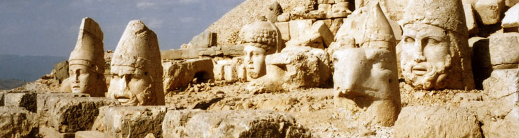
We continued on to Nemrut Dagi, through long and steep winding roads. After the usual "pit stops" along the way, we finally disembarked for an energetic climb up to the remains of a courtyard self-dedicated to the immortal importance of King Antiochos. Here we soaked in the magic of the architecture and statues as well as the effervescent efforts of Turkish school children to improve their English. My favorite statues were the heads of King Antiochios and Kommagene (goddess of fertility) who gazed serenely into the distance despite all the commotion. We took a group picture and watched the sunset before heading back for the long ride home.
After several appeals to Rafet for help, he finally suggested we say/sing "iyiki dogdun Lale." I think we were able to master this admirably and looked forward to surprising Lale on her birthday the next day. We ended the day with a late dinner at the hotel and a small celebration for Sarah and David's 39th wedding anniversary.
day 6 - June 10 - Ataturk Dam & Urfa - Sandy Prescott
On the bus to the dam, Mary Lee sees geological terraces that have been mined - perhaps, she speculates, to provide gravel for dam construction. As we enter the administrative building the women head upstairs to use 2 spacious clean and luxurious restrooms - lovely!!
After a speedy slide show by one of their PR staff, we bussed to the top of the dam. The color of the water is so striking I spend the first several minutes just trying to find the right word - turquoise? But the turquoise stones I see in jewelry are greener. Aquamarine?
On the far side of the water we can see Mt. Nemrut through the heat and haze. Swallows dart about the dam walls and schools of fish make paisley patterns as they chase after the leblebe Tan is dropping over the railing.
Amidst the scattering of Turkish and bus-based tourists, a family in Harran dress stands out. They each take turns snapping a photo of the rest of the group. I try to convey in gestures that I would be happy to take a picture of them all with their camera, but they seem uncomfortable. Later, Lale and Tan tell us that they spoke with the family as well as they were able, since the family spoke a mixture of Turkish and Arabic, and recounted this incident as an example of how peoples from the different regions and traditions of Turkey can retain their identity yet respect the different customs of others…. When Tan kissed Lale, the husband commented that in their neighborhood that would be seen as indecent. Yet they had a friendly relaxed discussion about our travel plans to their town.
As we approached Sanliurfa, Lale recounted the chaotic history of wars that marked this region's history: from the Romans, to the 50+ years of Arab rule at the end of the Byzantine period, the Seljuks in 1082, the Crusaders from the end of the 11th to the mid 12th centuries, to the Ottomans in 1516, and the French and British in World War I. Many of us are finding the food here much spicier than that of western Turkey. The local specialty is "isot" pepper, very hot.
Abraham and Sacred Carp Local legend has this as the birthplace of Abraham. Lale recounted that story for us as we stood by the pools of carp in the gardens at the foot of the castle. Many Turkish tourists filled the gardens in the relatively cooler air of late afternoon. As we listened, a young Turkish boy fell in as he was feeding the fish; his father had to jump in after him. The "sacred carp" in the pools represent the transformation of the burning wood. The square tower at the corner of the pool (originally a Christian church, later converted) purports to mark the spot where Abraham landed.
Nearby is a cave many believe to be the birthplace of Abraham. According to Lale, scholars can't agree on Abraham's specific birthplace - there are a number of towns called Ur in the region. But he did spend 15 years in Harran, where he married Sarah. Moslems revere him since Mohammed is descended from his son Ishmail. In the Koran, all the "people of the scripture" come from Abraham's sons Isaac and Ishmail. The story was first written down in the Old Testament. During the long periods of Moslem rule, this "city of prophets" was made a center of learning. Near the pool are several mosques.
An Islamic theologian who was a contemporary of Ataturk, Saidnursi, was buried at the end of the Pool of the Sacred Carp. However, political disorder amongst his many followers resulted in the grave's removal. He still has millions of followers who formed a controversial group [I'm still confused about why they were considered controversial] called "Following Nir." This wealthy group does works like building schools in the former USSR. Several years ago the Turkish prime minister invited the leader of this group to a dinner given for major religious leaders - this was seen as very controversial.
Pigeon-Betting - Tan took us to a mystery location, a place where women usually do not go. We wound through narrow alleys of the closed market to a steep old narrow staircase. At the top were the tables of a coffee house. At several, men sat and played dominos while Tan and the proprietor, Mehmet, explained its unique 100-year history. This place has functioned as a kind of pigeon "stock market" where pigeon fanciers from all of Turkey and Europe would race, bet, and buy and sell the birds. This is the biggest such site in all of Turkey.
One weekend in November, at 3:00 p.m., some 3000 birds would be set free, and then each owner calls his bird back to its nest. The birds return at sunset. The practice is that if a bird prefers to return to a different nest, it then belongs to that new owner; no one disputes this, it's the rule of the game... Then Mehmet laughs and says, "If your woman is beautiful, don't let her out; if your pigeon gets out you won't get it back. "One bird recently sold for some $3,000.
We are taken to next story of the building where some pigeons are caged and ask, how do you tell them apart? Some birds wear earrings or necklaces; many are banded on a back leg. But an owner knows all his birds, we are assured; and every bird has a name. The two partridges in wood cages are used as hunting decoys. Male and female pigeons are separated so the males are trainable. Another quip from Mehmet: "like in the military."
A young boy sets loose a cloud of birds for us. They circle and circle. Meanwhile, a female bird walks in front of us, to attract the group back. One by one they start lighting. I look out across the flat roofs of the neighborhood, seeing other boys and men and birds, and think that there is another world up here on the rooftops that tourists would rarely be aware of.
day 7 - June 11 - Sanli Urfa & Harran - Steve Rathfon
I was awakened from a light sleep by the muezzin's first call to prayer. The bright light of the dawn is soon penetrating the white translucent curtains and beckoning me to rise and greet the day. It's day 7 of the Eastern Turkey tour and we have an early departure for the biblical village of Harran, about 50-km southeast of Urfa.
At 8:50 a.m. we step off our air-conditioned sari otobus to a dusty dirt road at the citadel on the edge of the village. Fortunately, we have a gentle wind cooling us as we begin our walk through the village to the ruins of the ulu cami or "great mosque," (a center of learning built in 8th c. AD by Caliph Marwan II). We are soon surrounded by children ranging in age from about 5 or 6 up to probably 12 years. Several offer to be our tour guide, others offer hand-made items for sale, and a few simply beg. Despite little encouragement, they hover around us throughout our tour.
The ruins of the cami are impressive. A few walls, arches and a square tower (possibly a minaret or bell tower) remain standing. Tankut tells us that these ruins were as a secular university that became a center of learning renowned for translating Greek documents to Arabic. The curriculum included religion (Sabi, a mix of Christian and Muslim), science, math and astronomy. The university functioned in Harran for only 60-70 years then relocated to Baghdad.
Tan gave us a short history of rulers of Harran over the centuries and shared a legend about King Abgar V being healed of his illness and blindness by Jesus Christ. While there, Jesus washed his face and dried with a white handkerchief. The handkerchief became a religious relic and was taken to Rome by crusaders.
The village's importance declined after about the 10th c. AD. Its population dwindled to about 1200 people eking subsistence living from the fertile, but arid land. This marginal existence endured until the 1990's when the GAP water project began the delivery of water from Ataturk Dam to the fields owned by the villagers. Irrigation has turned this farmland into one of the most productive areas in Turkey. Now, Harran grows four times as much food as previously and a much wider variety including wheat, barley, vegetables, and fruits. The population has grown to over 6000 people all of whom now live in new modern housing outside the walls of the old village. The unique "trulli" beehive houses that distinguish this village from any other in Turkey are now used for storage.
After touring the cami ruins we were introduced by Lale to a young girl named Ceylan who, like many of the children, had moved to the village with her parents from near Urfa to work in the burgeoning agricultural industry. They came with the introduction of irrigation to become sharecroppers on the village lands (owned by Arabic families through several generations). As sharecroppers they farm the land and receive 30% of the crop. The owner, who provides water, fertilizer, etc. gets 70%. Only the exceptional child goes to school since the only possible jobs will be to work in the fields.
Ceylan and other children supplement their parents' income by making good luck charms from string, tatters of cloth, and uzerlik (small, inedible peas that grow as weeds throughout the village. Several of us bought these charms then began to wonder if we could get them past customs. The children's sales pitch was that their charms were better and cheaper than at the tourist center in the village-i.e., buy direct and eliminate the middleman. It worked...
We then met with Halil Ozyaruz, proprietor of "Harran Traditional House" a beautifully preserved beehive-style home built around a central courtyard. Halil spent nearly an hour answering our many questions about construction of the trulli home, the farming practices before and after irrigation, and the farm tools displayed on his walls. The traditional house of Harran consists of several connected rooms (the number probably determined by the size and wealth of the family) each built of stone walls about 6' high and topped with a large beehive-shaped dome about 9' high made of ever-decreasing circles of stacked bricks. It was unclear if the bricks were made of fired or sun-dried clay because according to Halil, the homes were constructed from the buried rubble of past centuries. Afterwards he invited us to tour his house.
On the return trip to Urfa, Tan pointed out several large earth mounds rising from the otherwise flat farmland. These are "tells" or farm villages abandoned centuries ago and their mud-brick structures dissolved into a heap by rain over time.
This evening we had dinner in Urfa Evi-a beautiful stone mansion once owned by a wealthy family and now owned and operated by Urfa City. The mansion is approximate 120 years old and filled with stained glass, and fine furniture. It operates as a pension and restaurant (Cardakli Kosk) with outdoor dining available in a courtyard and on a terrace overlooking the Kale.
We stuffed ourselves with salad, soup, kofte, kebab and bread topped off with melon, cherries and Urfa's famous kunefe (unsalted soft cheese covered with shredded wheat and soaked in syrup, then baked). This glorious day ended with the evening call to prayer an hour past sundown more or less.
day 8 - June 12 - Mardin - Carole Rathfon
Yet another scorcher dawns as we begin our trip to Mardin, a town of 600,000 in the hills near the Syrian border. Mardin's economy suffered greatly after the Gulf War because of the embargo on transporting Iraqi oil and products to the rest of the country, but now seems to be improving.
Mardin means "The City of Castles" in Arabic. It's a city of beautiful yellow stonework buildings carved from the local calcareous limestone. There is a saying that "Mardin houses only live with people inside" because the stone crumbles if not exposed to air. Tunnels (which are called "abbara"), with houses above them, provide shady passages for people to move through the town out of the reach of the searing sun. But not even Rafet can drive a bus through some of these narrow winding streets! Garbage trucks can't make it either, so municipal donkeys are employed by the city to collect the garbage (…but who picks up behind the donkeys?). We were happy to learn that the donkeys do get a good pension when they retire.
Mardin was a last minute change to the itinerary as Lale got an email message from a woman named Ebru who was a former secretary of the chamber of guides. Ebru, who attended university in Istanbul and then married, felt that her life was unfulfilled so she went back to her homeland in Mardin with a new mission. She organized the women of the city to clean up the Casimia Medresse, which had been used for a stable, and start a tea cafe for tourists. Because there was no decent hotel in Mardin, she used a home built for teachers as a hotel for tourists. She taught the local women about cooking, sanitation and how to make their homes comfortable for visitors. It has been an uphill battle. The town is very traditional and conservative and did not take kindly to her efforts. At first, she was threatened by local landowners but now Ebru provides employment for 30+ women of Mardin.
About that conservatism... Tankut filled us in on the local people and their traditions. They seem to feel isolated and abandoned by the Turkish government and have no tradition of working together for the public good. According to Tan, they have a strong resistance to new ideas and want to keep their old ways. They believe in "fate", sometimes to the point of rejecting modern sanitation and healthcare. Families are large (often 10 or more) and family planning is thought to be "against manhood". Many believe that "Allah will provide for however many children you have". The Hatfields and McCoys are alive and well in this countryside...
Usually the Aga's( feudal landlord) political connections provide him with subsidies and he has a strong bias in favor of maintaining the political status quo. Even though Ataturk tried to change this system back in the early years of the republic, it still continues. Steven, who has two unmarried daughters, was quite interested in learning about "baslik" which is the money to be paid by the groom's family before a marriage (the amount is determined by the father of the bride based on his social status). Relationships between men and women are constricted before marriage. There were a lot of questions from the women in our group about eye contact, shaking hands with males and other things that seem so natural to us.
Feeling a bit overwhelmed by all this information, we were delighted to go with Ebru to Cemil's beautiful home for lunch. We were interested to learn that houses in Mardin are named for the person who first built them, no matter how long ago, and that earthen pots are put on top of the interior arches to provide insulation between the ceiling and the dirt and stone roof. Ebru and the family made us feel like VIPs by showering us with gifts of scarves, pistachio oil soap, hand made loofas, and special cookies. Then they served us eggplant with sumac; dolmas stuffed with sour cherries, rice and almonds; an eggplant and coriander dish; and a special baklava consisting of 11 layers of filo dough, custard cream and pistachio.
Then we walked to Nasra's, all the while blending inconspicuously with the locals… Nasra is an 84-year-old national treasure. She is an Aramaic Syrian who hand paints church hangings using natural dyes and techniques that are a family secret. When Nasra dies, this art will die with her because no one in her family wants to continue the tradition and she won't teach an outsider. Nasra and her family members made the hangings and curtains that adorned our next stop…the Church of the 40's…a functioning Syrian Aramaic church.
All the church decorations were handmade, and in addition to Nasra's work, we especially admired a naïf painting of a group baptism done with wit and style. You could tell each man was a unique person, and many of them looked wet, about to drown, or ecstatic.
Isa, one of the priest's 13 children, welcomed us to the church and answered our many questions. Priests can marry and are elected by the community. Community donations pay for support of church and the priest's family. Wednesday and Friday services are optional but prayers must be said seven times a day. Children are baptized. Communion is required twice a year. The language used in the service depends on the community being served, but the hymns and daily prayers are in Aramaic so it takes a great deal of study to be able to lead the service. There are specific prayers for each day, prayers can be sung in any of 8 different melodies, and a melody is used for a whole week. Isa responded graciously to our request that he sing the same prayer in several melodies so we could hear the differences.
After leaving the church we walked through Tatlide Evi ("sweet granny's house"), a 250 year old stone house with gorgeous stonework, stained glass, and antiques. We admired the Great Mosque of Mardin and its minaret decorated with teardrop rain prayer designs. Then we checked out the tailor, spice and crier markets. What did you do if you wanted to sell something before the days of classified ads? Go to the "Market of the Criers" and rent a crier to walk around the market place letting everyone know what you wanted to sell.
On our way to the Deyrul Zafaran ("Saffron Monastery") we saw a large sign on the hillside saying "Ne mutlu Turkum Diyene"…"What joy to the person who says I am a Turk". The slogan was coined by Ataturk to encourage national pride.
Local legend says that the saffron monastery got its name because saffron was mixed into the mortar holding the stones together, giving it a yellow color. Father Gabriel, a man with a wry sense of humor, didn't confirm this, but he did lead us down into the original sanctuary which in 2000 BC was dedicated to a sun god. The dark low ceiling was cut from stones a weighty two meters thick and was held in place, not with mortar, but by a huge keystone. Not a good place for claustrophobics! The monastery went through several changes as it was abandoned or destroyed over the years and was once the seat of the Syrian Orthodox patriarch. In the 6th c AD Jacobus Baradeus disagreed with the patriarch in Constantinople over the nature of Christ and he established his own church in the monastery. Because Jacobus led them, other groups called them "Jacobites", but they prefer to be called Syrian Orthodox.
day 9 - June 13 - Mardin to Diyarbakir - Tom and Shelly Radsminski
We are now on our way to Midyat to see the stonemasons, which keep the art of intricate stone carvings alive. Lale says they created the new altar at the Deyrul Zafaran Monastery, now 70-years old - beautiful. Midyat is also a mixed religious community. The town consists of a Muslim part (Estel) and a Christian part known as Midyat. Ethnically, the people are of Arabic and Kurdish origin. Midyat is known for its stonemasons. The city is almost as large as Mardin - 60,000 people .In 1998, 6 stone artisans were found and brought out of retirement by the governor and the enticement of modern equipment. The 6 now have several apprentices. They were brought out of retirement to restore a Syrian Orthodox home. With the combined efforts of church, government, and the 6 stone artisans the art was reborn. Now people order carved stones from as far away as the US. A typical fireplace would cost ~$325 US, not including shipping - also inexpensive by slow boat.
Hasankeyf, our next destination, is filled with cliff-side dwellings - a very important city of Mesopotamia that controlled Tigris river trade. The current population is mainly Kurdish, but speaking Arabic. The Ilius Dam, part of the GAP project will cover this whole area soon if nothing changes. Until the 1960s the people of Hasankeyf lived in the numerous caves that are built into the hillside above the Tigris River. At that time, the president of Turkey decreed that a modern town be built here. During the project, 2 families were overlooked and still live in the caves today. We had lunch in a cave restaurant by the river of fresh grilled fish (called 'sabot' in Kurdish), flat bread, peppers and lots of watermelon.
After lunch we toured around the city's ruins with a 16-year old local who is the best student in his class, Mesut Olcay... Mesut is one of five children and he is very grateful to be sponsored by a family in Istanbul for college. He even has a computer and email address to get him started.
On our tour we saw the remnants of a beautiful arch entrance with a snake and scorpion (now mostly gone with time and decay). Passing under the arch protected you from those two pests. Since we were passing after the scorpion was gone, we were only half blessed. There were approximately 5000 caves in the area. Only two families still live in the caves. They were accidentally passed by when the government came through and built modern housing for the village (oops!). The rest of the caves are now used mainly for chicken pens and an occasional restaurant and shop. The caves are naturally cool and the view is beautiful of the Tigris river - no wonder people have lived there for so long.
We found shards of pottery from generations gone by. If and when the dam goes through, the rock these caves are built out of will dissolve with the water and all will be lost.
Leaving Hasankeyf, we have a rest stop in the city of Batman (yes, Batman), then on to Diyarbakir - land of copper. There have been 35 civilizations here. We visited the massive basalt city walls that are circa 4th century CE. The walls run for some 5800 meters, have 38 towers and 7 gates. The walls are built of two kinds of basalt: "male" basalt on the walls (no pores) and "female" basalt on the ground/floor (pores).
Touring with us tonight is Metin Nazlican, partner of Ebru Dokmen, a native of Diyarbakir. After the tour of the city walls, we had dinner at a restaurant where Metin and his brother cooked the main dish for us: stuffed lamb ribs. Another wonderful meal in Turkey.
day 10 - June 14 - Diyarbakir to Van - Mary Scandifio
Leaving Diyarbakir at 8 a.m. going to Batman, then on to Van for two days. The drive is 250 miles and this is the day we'll have a swim in Van Lake. We made a stop on Malbabi Bridge on Batman Creek to see another of Turkey's great dams. The children were diving and swimming into the creek below.
To give us all something to think about, Tankut had a political discussion on the drive to Van. Mary Lee Gillam gave us geographic facts of the mountains that we were passing through. It's remarkable how cities are built in the rock. Bitlis is one of the mountain villages of 38,000.
Lake Van is blue in color and the largest lake in Turkey. Beautiful! After passing the lake and continuing through the mountains, the hillsides start to become flush with greenery and flowers of yellow, purple, and a little red poppy. Glaciers can be spotted at the top. And we start to see little villages here and there as we continue.
The drive through the mountains has been a wonder to behold. Thanks to Rafet's driving, we're all safe. We arrived at the ferry boat landing and everyone got on the boat for the island of Aktamar Adasi, the largest of all the islands. On this island was a castle and the Adkmar Church, built in early 900 AD. We looked over the ruins, had lunch, and Sue and Brad had a swim in Lake Van. Then on the ferry boat back to shore and on the bus.
Next stop, Van Rock, where there is Kale Fortress, 825 BC, built by Urartian King Sardur I. There are 12 burial chambers carved into the rock. Tankut took the group up the rock to tour the fortress. Everyone back on the bus and drive to Van and check into the hotel. Lale introduced us to Burhan, who will go with us to the Nomad tents tomorrow. He joined us for dinner and then on the bus back to the hotel and sleep. Iyi Geceler.
day 11 - June 15 - Van, Deep In the Heart of... Turkey - Tyrrel Grohman
I am pilgrim. Do you have a new name? We have traveled across the center of Anatolia in our yellow land schooner to find ourselves awaken in Van. Büyük Urartu Oteli has been a haven for our tired but fulfilled bodies. Yes, more cucumbers and tomatoes with bread and cherry jam to start our day chatting with our SRM family. Rafet ready, we mount our wings to soar over Eastern Turkey safely in Rafet's hands. Our captains, Tankut and Lale, are joined by Burhan and Neriman and their nephew, Ahmet, who studies computer science at Arizona State University.
We glide by Lake Van, Van Gölü, on our left, surrounded by towering mountains, some still blanketed by tenacious snow on their peaks. The water is the color of a single cat eye [Ed. Note: Tyrrel didn't indicate which eye] and tranquil. Our hearts ponder the adventure today-visiting Kurdish nomads. How will this turn out? Can we build a bridge again today with our language impediment? How beautiful will the people be this time?
We are briefly delayed-stopped on the main highway by a herd of sheep and donkeys with two shepherds crossing the road. Suddenly, we turn onto a dirt road and find two white "rowboats" ready to take us ashore to the top of the mountains. We have rescued one voyager afoot to travel with us. A young turbaned man with shimmering dark eyes, a wide grin and no name. We stopped to add three lovely sisters, well clad, to our number as well as several other new friends.
First, we must align the holes and relieve ourselves. Small calves on the other side of the fence... Now ready, we push upwards, passing flocks of sheep and a few shepherds.
There it is on top of the plain, a whole village of goat hair tents! Fifteen Kurdish families and 10,000 head of livestock here for the summer. They return to Batman to escape Jack Frost's assault in winter. We gather around Lale and Tankut like baby chicks with their mother for instruction. "You are on your own. Buses leave at 12:10!" We all explore in our own manner with our third eye flashing to capture the treasure placed before us.
We hesitantly approach these tents and their occupants. We sign out our benign intent to our quarry and push forward-entering under their roof-accepted for this brief time. Burhan has a magic key to unlock the nomads' mysteries to our eyes. Simple life - cooking utensils, pillows, rugs, clothes, cheese - where would all our stuff fit here?
Saturday Night Fever arrives a day early when Tom and Shelly take Polaroids and give them away. Tankut shares jerky with the men. Some wander over the creek to see the sheep milked and even try to milk. Time stood still, time has elapsed! We must accept the brevity and rejoice over the opportunity to demonstrate our friendship with hard copy to show them we care.
We glide down the mountain to enjoy a lunch feast. Shoes off, sitting in the shade around the huge ground cover. Flat bread, salad to start. Bottled water-thank goodness-and Tankut and Lale. Now the main course-stewed lamb, another sacrifice for us-the aliens-with rice and raisins. Karpuz for dessert-juicy, red, luscious.
Leaving in 15 minutes. Time for another goodbye... Final pictures taken and hands shaken, we retreat from another mountain top only to remain aloft in our spirits at the wonder of such an opportunity. We race back toward Van, only to turn off to visit Kedi Evi-Van Cats -white, and each with one blue eye and one green eye. Tiny kittens... another treasure to put in our "chest" of memories. Each will continue on their chosen path, but will savor the sights, sounds, smells, and memories of our time together in Eastern Turkey with our bridges-Tankut and Lale. Now, we can be a bridge builder with our words, photos and attitude. We must "interpret" what we have seen in our own ways. These footprints can never be duplicated!
Hoca is calling out for his lost donkey and then shouting, "Praise the Lord!" A friend asks him, "Your donkey is lost. Why do you thank God for that?" Hoca replies, "Yes, my donkey is lost, but if I were on it, I would be lost too!" Is your donkey lost?
day 12 - June 16 - Van to Dogubeyazit - by Mary Gillam
Today began bittersweet. As we prepared to board the bus, we said our last goodbyes to Alicia and Tyrrel, who are flying home today so Tyrrel can work on Monday. Privately, Alicia wonders if he will stay awake after long flights and a 3-hour drive. Who will keep us laughing and help us down from the back door of Buyuk Sari otobus?
From Van, we retraced our previous route along the east side of Lake Van, past the turnoff to the villages where we spent much of yesterday. As we continued northward, we enjoyed beautiful views of the deep blue lake and a snow-covered volcano, Mt. Supan, on its opposite side. Features indicating the higher shoreline of glacial Lake Van include horizontal, wave-cut benches along the lower slopes, rounded beach gravels, and light-colored, thin-bedded deposits that formed under water.
Soon after we began to climb the valley leading northeast from Lake Van, we stopped at Muradiye Falls. Perhaps 10,000 years ago, lava flowed down the valley and formed its flat floor. Muradiye Cayi is still cutting through the lava, and the falls mark a step in the creek's profile. White travertine coats the black basalt beneath several ribbons of water. Just below the falls, we crossed a suspended footbridge that swung drunkenly when too many people walked on it at once.
From the Van area, where folded marine limestone and shale are visible in places beneath volcanic rocks, we progressed toward areas where volcanic rocks exclusively form the landscape. We crossed flat-floored basins surrounded by volcanoes of all sizes. From the abrupt topographic contrast between mountains and basins, it appears that unmapped faults ring the basin floors. In many places, young lava flows spill down the slopes. We also see light colored, soft air-fall tuffs. In villages, houses and walls are built from sawn blocks of gray tuff and chunks of basalt. Many fields, tilted crazily on the rugged lava flows, seem nearly impossible to farm.
As we descend from a high pass, we catch our first views of Mt. Ararat beyond Dogubeyazit. The city sits in a flat, fault-bounded valley that is ringed by mountains. At a height of nearly 17,000 feet, snow-capped Mt Ararat rises impressively some 10,500 feet above it. The mountain's broad shoulders and lower flanks are composed of cascading lava flows. The more distant summits of Mt. Ararat and Little Ararat are steeper, composite lava and cinder cones with glacially sculpted cirques and chutes. Geologic maps show that a large crack near the two summits is the source of so much molten rock.
In the afternoon, we briefly visit a "meteor crater" along the ancient Silk Route within view of the Iranian border. The hole is now about 35 m wide, has vertical sides in basalt, and lacks an ejecta ring. It looks unnatural and is not a crater according to Dr. Salih Bayraktutan, a geology professor whom I met later in Erzurum. To find this place, Rafet gingerly pilots the bus down narrowing gravel two-tracks. In his previous job, he drove a truck to and from Iran through the nearby border checkpoint, where today a long line of trucks waits.
From here, we go to the Ishak Pasha Palace, which is perched on a high knoll surrounded by much higher ramparts of nearly vertical, folded and faulted rocks. Their bright pink, green and tan colors beautifully frame the pale pink palace with its dome and minaret. Abdi Pasha began construction in the late 1600's and his son, Ishak (Isaac), finished the palace 90 years later. It had 366 rooms on one to three levels of which only the lower two remain. We examine the courtyards, harem (living quarters for the pasha's family), selamlik (day-use area for the men), courtroom, mosque, hamam, and kitchens.
Formerly plastered, the walls of smoothly cut tuff are broken by profusely decorated panels and frames for doors and windows. Unusual elements include the use of local flowers and trees in high-relief carvings and a hidden stairway to the mosque's pulpit. The building had central water, heating, and drainage systems, but lacked water cisterns - a surprising oversight, because it was besieged often and changed hands 23 times during Ottoman rule.
After a cool and windy afternoon, we return to our hotel for a simple dinner, sated by the day's many sights.
day 13 - June 17 - Dogubeyazit to Kars & visit to Ani - David Hill
Our group awakens to a nearly clear view of Mt. Ararat with its peak nestled in a thin cloud but the peak is clearly visible - a treat since it is nearly always shrouded in mist. Actually there are two peaks - Great Ararat is 5165 meters and Little Ararat is 3925 meters. Noah's ark supposed came to rest here after the great flood. Ararat is important as a spiritual axis for the Armenian-speaking people that have emigrated from this area to distant lands. The Armenian Republic to the east of Turkey is only a part of the area populated by these people in the past. Only a small population of Armenians remains within Turkey today. Armenians were relocated in 1915 outside of Turkey at tremendous loss of lives to both Armenian and Turkish peoples unfortunately caught in international and local political disputes. - A terribly sad period for both groups and our own civilization.
Our hotel is on the south slope of Mt. Ararat and we head east and then north as the mountain is on the eastern Armenian border. The mountain is a long dormant volcano. We ascend over foothills free of lava on the southeastern slope. Crossing the highest ridge broken basalt lava flows spread like fingers into smaller valleys. The country becomes more desolate with isolated small one-room mud huts. About every twenty miles military police stop to check our group passport documents in their lonely outposts. Most count the days until they return to civilization. Night duty would seem dull beyond words. The road turns white with one-inch ice balls: we have just missed a hailstorm which left a white crust several inches in thickness that extends for several miles.
We pass immediately beside the Arpacay River separating Turkey from Armenia and drop into Kars, passing solid stone block buildings constructed by Russians at the turn of the century. Small shops with dark interiors do not beckon shoppers. In the afternoon we visit Ani, the historic capitol of the Armenian kingdoms nestled on the bank of the Arpa Chay River. We are forbidden to take pictures in the direction of the Republic of Armenia across the water and give up our passports to guarantee we won't take a swim over the border.
Present day Ani is a ghost town surrounded by towers and walls that are massive but little remains of the city. It has the feel of Pompeii unreconstructed. During the 9th to 12th centuries it had a population of 100,000. The Cathedral with its fallen dome and soaring arches to the heavens exemplifies Armenian architecture. These classic churches have a relative small base but soaring interior space pointing into the heavens. It is impressive. We also examine other churches with partially intact frescoes.
Ani is on the silk route and has a caravan serai. There Sarah has recognized an Armenian cross similar to a purchase in Ankara. It has been the cross roads of commerce between east and west. In it's time it was rival to Paris and Constantinople in architecture, commerce and the arts. A millennium past, this city was capital to an Armenian kingdom similar in size to the present Republic of Armenia and the northeastern part of the present Republic of Turkey. It was built on a spectacular plateau encircled by deep ravines and Ani's countless palaces and churches were far technically advanced for her time. It has fallen to ravages of earthquake, Mongol, Seljuk, Russian and Turkish invasions being at a historic geographic crossroad of many hostile civilizations.
day 14 - June 18 - Kars to Erzurum - Richard Reed
A long, morning on the bus from Kars to Erzurum, 130 miles of gently rolling green hills with fields of the most beautiful wild red tulips I have ever seen. We had to stop and take pictures.
Erzurum is now a university town with 60,000 of its 300,00 inhabitants being students. Erzurum in the winter is a city for skiers, Hundreds of years ago it was a frontier province (like the Wild West) that valued the holy trinity above all: horses, weapons, and women. After a short stop at the hotel in Erzurum to unload our bags, we were off to the old part of Erzurum.
Our first stop was Cifte Minareli Medrese or the Twin Minaret Seminary which the wealthy Seljuks built in the 1200s. Most impressive were the paneled facade with its symmetric variations and the twin brick minarets decorated with blue titles. This 13th Century seminary is now a handicrafts market and a café. Next stop was just down the street, Ulu Cami, an early 12th Century Mosque build on the medrese plan-a forest of columns with probably a pool in the center with an opening on top.
We were then let loose for the rest of the afternoon to explore the old town for ourselves. Dinner that evening was very special. It was our last night with Rafet. He was presented with several gifts, but one was very special. During the day on the bus Carol had made a wonderful colored drawing of Rafet driving our bus with many recognizable travelers hanging out the windows. Everyone was very impressed with Carol's work and Rafet said that it was the best gift that he had ever received. In addition, Steve presented Rafet with some toys and the plans and instructions to make more for his grandchildren when they arrive. Tour members shared stories of their purchases of the day including jewelry made from the semi-precious "coal" which is a specialty of the region.
> back to top
It's 5 p.m. and time for our Eastern Turkey group to meet in the banquet room of the Hotel Ickale. Most of us have either traveled to Turkey on the first trip together, or we met our travel buddies the previous night in the hotel lobby. All of us are alumni's of Lale's and Tan's Western Turkey tours. It's great to be among old friends. After a warm welcome, Lale introduced us to her former archeology professor, Dogu Mermerci. He will be conducting an educational tour to an ancient Hittite village tomorrow. We are to address him as hocam, (ho jum-"my teacher"). Tankut poured us all a glass of wine while Lale talked about the itinerary. We raised our glasses to toast to renewed friendships, new friendships and an adventuresome trip.
At 7 p.m. we adjourned to the hotel restaurant where we had an outstanding dinner of salad, stuffed squash, bulgur in spicy red sauce, lamb stew and a house specialty of honey pastries...
day 1 - June 5 - Ankara to Amasya - Hittite Empire - Lynne Curry
Today is much cooler as we tearfully wave good-bye to our dear friend Mary Ann, who must leave us to guide a tour in Europe. Our destination is Hattusas, site of the ancient Hittite capital called Bogazkale. We drove along for a couple of hours through lush green farmland, passing over the Red River (Kizilirmak) that flows through Turkey into the Black Sea. Along the way, our esteemed professor explains the history of the ancient Hittites and describes the first use of cuneiform tablets. The first types of written communication on stone tables were invented by the Syrians during the Bronze age.Tankut took the microphone and proceeded to tell us about the Turkish economy.
We reached Bogazkale around 10 a.m. From the bus one could look up the green hillside to the rock foundations of some 30 temples built by the Hittites. Our first hillside stop was at the Lion's gate-the main gate used by kings. You could still clearly see the grooves in the rock walls that were carved to allow the wheels of chariots to pass through. Inside the gate are remains of two large stone lions on each side of the gate. They stand ready to protect the city. The gates were built of wood and plated in bronze to protect them from burning by invaders. Today, local villagers display their hand carved stone lions, gods and jewelry for sale.
This Hittite city was surrounded by two defensive walls. The exterior wall guarded against outside invaders, while the interior wall protected the palaces. Further up the hill, we stop at the Tunnel Gate. This massive 220 ft triangular tunnel extends through the defensive wall, slopping downward into the city. The professor points out the tight fit of the hand chiseled blocks on the retaining wall. Walking along the top of the wall, we came to the Sphinx Gate, named for the 4 Sphinxes carved into the corners.
We asked hocam what was the population of Bogazkale at its most prominent time. He told us that it was not possible to estimate the population. The guidebook that most of us bought says there was no record of the population in any known documents. Also the uneven terrain, the distribution of the city on artificial terraces and the presence of large temple areas in the upper and flower city make even an estimate impractical. The area had been settled during Paleolithic times, although evidence shows Bogazkale was occupied around the second or third phase of the Early Bronze period.
Back on the bus, we drive about 500 yards past the Kings Gate. We proceed downhill to the Great Palace, the most intact of the ruins. The site was also a library for 10,000 cuneiforms. Hocam pointed out the cisterns, storage areas, and river below called Deep Throat. In front of the Great Palace stands a large cuneiform rock tablet with Arabic hieroglyphics proclaiming the king's deeds. Rocks used to build the palace come from a quarry just behind the city gate.
It's early afternoon, so we stopped at a small town of Asikoglu for lunch. Tankut gave us the green light to try as many dishes as we like in this cafeteria-style restaurant. The food was delicious. Refueled, we were back on the bus headed for the Open Air Sanctuary (Yazilikaya).
The roofless, rock cut, triangular sanctuary contains three rooms. Each has carvings of famous deities of the Hittite period. Hocam names the Hurrian name of each of the 63 gods. The first 14 are Mountain Gods. Next are sun, moon, weather gods, 2 maidens of Goddess Ishmar, war gods, water gods, etc. The great King relief is that of King Tudhaliya. The sanctuary is the sacred place that priests may bring the ash remains of former kings.
We left the Open Air Sanctuary and drove 16 km to the summer palace of the Pontic Kings. This palace was built in honor of the sun goddess Arinna. Dogu did some excavating at this site in the 1970's. He proudly points out the stones he researched and identified.
It is late afternoon now, our head numb with fascinating details. Dogu bids us adieu. Our thoughtful Texans, Alicia and Tyrrel, presented the professor with a card and Texas flag in appreciation of his time and expertise shared with us. Dogu was very touched by this show of appreciation.
In Amasya, the group split up-one group stayed in a small pension, the other in town at a small hotel. Dinner was a lovely home cooked meal in the cool garden at the pension. Our hosts are both pharmacists and have a lovely, young daughter who speaks English quite well. Tired and full, we're off to bed for a goodnight's sleep.
day 2 - June 6 - Amasya - Sue Larsen
Our first day in Amasya starts leisurely with a late breakfast. Tankut and Lale then lead a group walk through the town of Amasya to show highlights of the town and preview it's historic past. The first stop is the Gök Medrese Camii (1266) and the Tomb of Torumtay (1255 - 1320) where the group gets a brief summary of the history of Amasya and the Black Sea Region of Anatolia.
From the Bronze Age onward Hittites, Assyrians, and Phrygians inhabited this area. In the 3rd Century BC. Amasya became the capitol of the Pontic Kingdom and dominated most of Anatolia. Amasya was the birthplace of the historian Strabo (circa 63 BC). In 47 BC, the Romans invaded the area and during their occupation Amasya was a major garrison town. Following the Romans were the Byzantines then the proto or Seljuk Turks in 1174 AD. Islam became the primary religion as a result of this last invasion and has remained so to the current day.
The Mongolian invasion in the 13th Century resulted in the decentralization or fragmentation of the Anatolian Empire. The 14th Century marks the foundation of the Ottoman Empire finalized by the fall of Constantinople to Sultan Mehmet II in 1453. The end of the Byzantine Empire marks the end of the Middle Ages and the beginning of the Renaissance.
Under the Ottomans, Amasya became the city of the Crown Princes, with the candidates to the throne being sent to this area for their training. Varying reasons for the decline of the Ottoman Empire were discussed, one being the process (s) for the selection of the successor to the throne. As these processes changed under political pressures of the time, instability and internecine struggle became the order of the day. On June 12, 1919, Mustafa Kemal (Ataturk) organized a meeting at Amasya to signal the start of the War for Independence. Amasya still celebrates that date. At the onset of the Republic, approximately 95% of Turks were illiterate.
Ataturk banned the Madressahs, which were the schools for religious studies and education became secularized. At that time, the Gök Medrese Camii was converted to a museum. The eyvan serving as its main portal is unique to Anatolian architecture. It is known as the Sky Madressah Mosque due to the turquoise and blue tiles found on the exterior. Today it is actively used.
Next we proceed to Amasya's primary mosque, that of Sultan Beyazit II, dated 1485. The mosque complex incorporates a library, medressah, kitchens and garden areas. Tankut describes the transition of mosque architecture from the madressah to the classical "Kulleyi" construction as seen in the Sultan Beyazit II Camii. The group is able to meet the muezzin who explained the calligraphy found in the interior of the mosque. Tankut next takes us to an old madressah to show an example of the early evolution of a caravanserai to madressah (14th-15th C.) to a now functioning workshop. Much of the original brickwork is still evident.
Just adjacent to the workshop Tankut points out a fine example of late Seljuk masonry in the Burmly Minare Camii (1237), currently an active mosque. This same stop gives us our first photo op of the Pontic tombs and Citadel which overlook Amasya from the opposite side of the river. The tour ends for the day with suggestions for further activities.
Several of the group cross the Yesil River and proceed to the Pontic tombs, which were built prior to the 11th Century BC. These 5 Kings Graves are carved from the sheer rock face high in the cliffs overlooking the city. The lower of the tombs, one being the "Mirror Cave" Aynali Magara, was a pleasant walk up sculpted steps in the rock face. A marvelous rock cut cleft passage gives easy access between the two tombs. We paused to appreciate the view of the distant city and take photos. As we are intrepid travelers, we head towards the remaining three tombs. We soon discovered that only a rocky goat trail serviced the tombs, which were much higher in the cliffs. After much grunting, pushing, pulling and generally sweaty athletic exertion we were rewarded with another spectacular view. What made the view even more breathtaking was there were neither guardrails nor safety devices whatsoever between the tourist (us) and the natural environment (valley floor).
We return to the pension for a tasteful dinner served by our hosts. Some finished the evening with a walk around town and to view some of the historic homes across the Yesil River. The Hatuniye Mahallesi area parallels the river and contains many old restored homes. Many are private residences and some are being converted to pensions or bathhouses.
day 3 - June 7 - Sarah Hill
The group was up early heading out for a most unique day. After our fascinating start out in Hittite country, we were ready for more. We headed out southwest from Amasya through beautiful, lush green countryside with lovely wildflowers and unusual, purple poppies.
On we drove through Tokat and Sivas. Many of the attendants in hamams come from these two towns. By noon we had arrived at a small side road northeast of Sivas where our guide from the remote village met our big bus. We were to be their very first American visitors and the whole village turned out to welcome us.
Our first impressions were of a very rustic village made of stone and mud houses with all these smiling faces greeting us. They had to move some rocks out of the road for us to finally park the bus where there was enough space. The dirt road was very narrow for "Big Yellow." Raffet saved the day.
We were immediately surrounded by most of the men in the village. We were to shake hands with each one and happily greeted them all with our very best "Merhaba's." The woman and children were not far behind. We could not have received a warmer welcome.
Immediately, the 13 ladies in our group were ushered up to the biggest, nicest house in town to use the "tuvalet." This house was only 2 years old and had been built for the parents of a son who had made money in Germany and provided very handsomely for his family. Gullu and Mustapha were very proud to have us sit and wait our turns in their newly furnished "parlor." The modern "tuvalet" was temperamental but Gullu aided our cause with extra buckets of water. After a complete tour of the house and its kitchen with marble counters, hardwood floors and beautiful wrought iron work and ceramic tile floors in the entrance hall, we were ready for their banquet.
Down the hill we all walked, accompanied by the village women who were eager to walk arm-in-arm with their new friends. Most of the women had their heads covered, wore traditional baggy pants and sweaters with a vest over it. A few had a gold necklace-again maybe a gift from a working son.
The men were already gathered by the very long table set up in the grass. They had real plates and silverware and flowers on the table. The villagers had all worked on preparing the food for us and we were very impressed to see they had slow-roasted two lambs in a pit. They were served whole on huge round trays. They just tear away pieces to serve you. The villagers enjoyed it as much as we did. They had also prepared huge pilavs for us-Lale says they cooked 5 kilos of rice. Their pilav was really delicious flavored with bits if liver, pine nuts & currants- mmmm. We also had the usual tomato-cucumber salad -so finely chopped it must have taken a whole day to prepare. They also served bowls of bulgur wheat with what seemed to be tomato sauce mixed in. They had diluted 4 kilos of yogurt to make our ayran to drink. We loved sitting in this beautiful place surrounded by the warmth of our new friends. The feelings were mutual.
After this remarkable feast we went to see where and how they make their bread for the village. It is in a stone house that is about 100 years old with a unique wooden roof that has a smoke hole in the top. Dough of flour, water and oil is mixed by hand and shaped into round balls a little bigger than a tennis ball. These are placed in a big pan like a dishpan. They have a wood fire that makes their oven, which is a convex round plate called a "sac." They flatten each ball and quickly bake their thin bread on this hot plate. It is turned with a flat stick called an "oklava" and the finished product is called "gozleme." This bread is often folded around filling of meat, potatoes or cheese or any combination of this and is called "borek." We had baskets of this flat bread for lunch so they obviously know how to do quantity cooking! It was fascinating to watch this timeless endeavor.
We continued on our way fortified by 48 bottles of water off the bus. Next we walked together with many village women up through the village past a well and their homes up to a field where there was a wonderful, new wooden gazebo complete with a fireplace and tables. We were served tea brought up by the girls and given a chanced to ask questions. This village would have as many as 5000 people but most have gone elsewhere to earn more money. Now children and the retired elderly who have money populate the village. They no longer have a school locally but 60% of the people have a university education. For a village that is 650 years old, most of the changes have occurred in the last 40 years. Concrete buildings have only appeared in the last 3-4 years. Many people work in metal, learned from the days when they were building the railroad to Sivas. They are self-sufficient food-wise and have 500 cows, 5-6 donkeys and 25 tractors.
A beautiful young woman named "Ismacan" wore the traditional dress of the village for us. Every woman would have one and these were worn at the yearly festival and weddings. Her dress had been made by an aunt and was very colorful. What a village of contrasts!
After the tea, we went up through the fields of beautiful wild flowers, past their cemetery and overlooked their beautiful valley. By five o'clock it was time for us to leave-we all shook hands with each person, tried to say goodbye and thank you in our best Turkish-certainly, the language of the heart filled in any gaps.
We collapsed on the bus going toward Kayseri. We passed beautiful snow-covered Mt. Erciyes which is 11,000 feet high. Very impressive, indeed. Culture shock hit big-time as we saw Burger King and McDonalds! This is a city of a million people and has long been a crossroad through history. Somehow, we managed to eat again at our nice Grand Eras Hotel. This dinner featured specialties of region such as "manti"-little handmade, meat-filled raviolis served with a tomato sauce and a dollop of yogurt. Another highlight was the "pastirma," which reminded us of our pastrami. This is meat coated with red pepper and spices. It is delicious. Cherries are just coming into season.
This has been a wonderful, unique day that will always be special to our group.
day 4 - June 8 - Kayseri, Mehmet Bey Village & Maras - Steve Thomas
Erciyes Dagi, 3916 meters high (about 13,000')
7:30 cereal, scrambled egg, tomato, cucumber, olives, yogurt. Breakfast with Rafet Kibar, who drives a bus 200,000 miles each year and has driven 15 million kilometers (about 9 million miles) in his 23-year career.
9:15-10:45 Visit Gevher Nesibe Sifahane (hospital) founded 1206 and Medical Medress (school), founded 1214. Princess Gevher fell in love with a cavalry officer. Her brother Sultan Gİyaseddin KeyhUsrev sent him to war to break up the romance. He was killed. Gevher mourned her lover's death, then fell ill with tuberculosis. Her brother apologized for his actions and promised to do anything for the princess. She asked that he use her inheritance to build a free hospital for the poor (1206). Soon after a medical school was established (1214) in an adjacent "twin" building. The teachers followed the techniques taught by Ninth and Tenth Century Persian doctors, such as Ali Sinasi, who first used anesthesia (wine and opium) and did the first successful Caesarian births on Raze, who found a cure for smallpox Their work was taught and extended in the Medressa. Advances included enemas, purging, lobotomy and more. Doctor Ianisine said "travel more, and find health."
The hospital and medical school functioned from 1206 until 1890. It was established by Erciyes University as a Medical Museum in 1982. We toured the mental hospital and surgical suite. A high school science fair was in progress and hundreds of sixth through twelfth grade students were visiting. They treated us as celebrities and crowded around. "Hello, what is your name. My name is Mahmut or Renay, etc. How old are you." We photographed them. They photographed us.10:45-11:25 Visit 2-door Mosque and Grand Bazaar.
11:25 Leave Kayseri city center going southeast. Tan lectures on the economy, political parties, privatization, etc.
2:30 Enter Mehmet Bey village, named for Lale's great granddad, who emigrated from the Caucasus Mountains about 1900. They spoke an Indo-European language (not Turkish). We met Lale's Uncle Nuri, and Aunt Nermin and other aunts and cousins. They served us lunch at the family guesthouse near the Terpuzek River. Lunch was flat bread, potato stuffed bread, cheese, stuffed (triangular) bread, meat balls, yogurt, orange juice, apricots and cherries. We also visited the main house, which is a family museum. Nuri has government position to try to keep the village as it is as a historical district. Took photos of Lale's family.4:15 Left Mehmet Bey.
6:30 Enter Maras, population 400,000.
6:45-7:45 Walk in Grand Market and watched a coppersmith at work and discuss his work. He was making a 3-foot diameter by 20" high "pot." He apprenticed at 8 and is now 36. Business isn't very good. Only villagers buy his pots.
7:45-8:15 Walked to ice cream store. I got a mixed Bacalava plate with plain ice cream and walnut ice cream.
8:20 Lale's note: We see my uncle (Nuri Surmen) quite frequently. I particularly try to keep in touch, because after his sons and their families left for other cities. I was left as the only young generation family he has got in Istanbul. If you have photos to send him, his address is in the appendix.
day 5 - June 9 - Nemrut & Adiyaman - Louise Lew
We began our day by exploring the market in Maras on our own. Brad became the brief apprentice of a coppersmith (Mehmet) we had met the previous evening. All the copper artisans seemed impressed by Brad's skill with the mallet. All too soon we returned to our "sari otobus" with our culinary and other treasures. My personal favorites were sucuk* a local delicacy of walnuts dipped in a grape and molasses paste (how do they get the walnuts to stick on the string?), and an inexpensive brass bowl ($3.50) decorated in Arabic that Lale's mother told me was the most important chapter in the Koran. She read it beautifully for me and I wished I had a tape recorder to preserve it for posterity.
Another highlight of the day was visiting Nemrut, a World Heritage site. We took our usual bus ride through the spectacular countryside, seeing wild oleander (the shrubs with pink flowers), traditional flat earth roofs (some with satellite dishes) and the animals and people going about their daily business. I looked at all the rocky land, and all the farmed land, and thought about all the back-breaking labor involved, and prayed to God that this would not be my destiny.
First we visited the tumulus of the black bird. The bird was originally painted black, but the paint has weathered away with the years; it was constructed of limestone quarried locally. You could see holes about 5 inches deep on various parts of the column, in which metal poles were inserted to lift each piece into place with the help of scaffolding. Originally these were three groups of three columns-one group of birds, one group of lions, and one group of bulls. Briefly, a tumulus is a hidden tomb which is covered by a huge pile of rocks. Tankut gave us some free time here and I wandered away from all the exuberant American and Turkish tourists. I enjoyed watching the swallows soar through the beautiful blue sky and listening to the sound of cicadas and the wheat rustling in the wind.
Next we visited the Septimius Severus bridge, constructed by the Romans from huge rocks removed from the no longer hidden tomb of the black bird. Three of the four columns remain, the fourth was destroyed by a jealous brother as it contained inscriptions dedicated to his sister.
We continued on to Nemrut Dagi, through long and steep winding roads. After the usual "pit stops" along the way, we finally disembarked for an energetic climb up to the remains of a courtyard self-dedicated to the immortal importance of King Antiochos. Here we soaked in the magic of the architecture and statues as well as the effervescent efforts of Turkish school children to improve their English. My favorite statues were the heads of King Antiochios and Kommagene (goddess of fertility) who gazed serenely into the distance despite all the commotion. We took a group picture and watched the sunset before heading back for the long ride home.
After several appeals to Rafet for help, he finally suggested we say/sing "iyiki dogdun Lale." I think we were able to master this admirably and looked forward to surprising Lale on her birthday the next day. We ended the day with a late dinner at the hotel and a small celebration for Sarah and David's 39th wedding anniversary.
day 6 - June 10 - Ataturk Dam & Urfa - Sandy Prescott
On the bus to the dam, Mary Lee sees geological terraces that have been mined - perhaps, she speculates, to provide gravel for dam construction. As we enter the administrative building the women head upstairs to use 2 spacious clean and luxurious restrooms - lovely!!
After a speedy slide show by one of their PR staff, we bussed to the top of the dam. The color of the water is so striking I spend the first several minutes just trying to find the right word - turquoise? But the turquoise stones I see in jewelry are greener. Aquamarine?
On the far side of the water we can see Mt. Nemrut through the heat and haze. Swallows dart about the dam walls and schools of fish make paisley patterns as they chase after the leblebe Tan is dropping over the railing.
Amidst the scattering of Turkish and bus-based tourists, a family in Harran dress stands out. They each take turns snapping a photo of the rest of the group. I try to convey in gestures that I would be happy to take a picture of them all with their camera, but they seem uncomfortable. Later, Lale and Tan tell us that they spoke with the family as well as they were able, since the family spoke a mixture of Turkish and Arabic, and recounted this incident as an example of how peoples from the different regions and traditions of Turkey can retain their identity yet respect the different customs of others…. When Tan kissed Lale, the husband commented that in their neighborhood that would be seen as indecent. Yet they had a friendly relaxed discussion about our travel plans to their town.
As we approached Sanliurfa, Lale recounted the chaotic history of wars that marked this region's history: from the Romans, to the 50+ years of Arab rule at the end of the Byzantine period, the Seljuks in 1082, the Crusaders from the end of the 11th to the mid 12th centuries, to the Ottomans in 1516, and the French and British in World War I. Many of us are finding the food here much spicier than that of western Turkey. The local specialty is "isot" pepper, very hot.
Abraham and Sacred Carp Local legend has this as the birthplace of Abraham. Lale recounted that story for us as we stood by the pools of carp in the gardens at the foot of the castle. Many Turkish tourists filled the gardens in the relatively cooler air of late afternoon. As we listened, a young Turkish boy fell in as he was feeding the fish; his father had to jump in after him. The "sacred carp" in the pools represent the transformation of the burning wood. The square tower at the corner of the pool (originally a Christian church, later converted) purports to mark the spot where Abraham landed.
Nearby is a cave many believe to be the birthplace of Abraham. According to Lale, scholars can't agree on Abraham's specific birthplace - there are a number of towns called Ur in the region. But he did spend 15 years in Harran, where he married Sarah. Moslems revere him since Mohammed is descended from his son Ishmail. In the Koran, all the "people of the scripture" come from Abraham's sons Isaac and Ishmail. The story was first written down in the Old Testament. During the long periods of Moslem rule, this "city of prophets" was made a center of learning. Near the pool are several mosques.
An Islamic theologian who was a contemporary of Ataturk, Saidnursi, was buried at the end of the Pool of the Sacred Carp. However, political disorder amongst his many followers resulted in the grave's removal. He still has millions of followers who formed a controversial group [I'm still confused about why they were considered controversial] called "Following Nir." This wealthy group does works like building schools in the former USSR. Several years ago the Turkish prime minister invited the leader of this group to a dinner given for major religious leaders - this was seen as very controversial.
Pigeon-Betting - Tan took us to a mystery location, a place where women usually do not go. We wound through narrow alleys of the closed market to a steep old narrow staircase. At the top were the tables of a coffee house. At several, men sat and played dominos while Tan and the proprietor, Mehmet, explained its unique 100-year history. This place has functioned as a kind of pigeon "stock market" where pigeon fanciers from all of Turkey and Europe would race, bet, and buy and sell the birds. This is the biggest such site in all of Turkey.
One weekend in November, at 3:00 p.m., some 3000 birds would be set free, and then each owner calls his bird back to its nest. The birds return at sunset. The practice is that if a bird prefers to return to a different nest, it then belongs to that new owner; no one disputes this, it's the rule of the game... Then Mehmet laughs and says, "If your woman is beautiful, don't let her out; if your pigeon gets out you won't get it back. "One bird recently sold for some $3,000.
We are taken to next story of the building where some pigeons are caged and ask, how do you tell them apart? Some birds wear earrings or necklaces; many are banded on a back leg. But an owner knows all his birds, we are assured; and every bird has a name. The two partridges in wood cages are used as hunting decoys. Male and female pigeons are separated so the males are trainable. Another quip from Mehmet: "like in the military."
A young boy sets loose a cloud of birds for us. They circle and circle. Meanwhile, a female bird walks in front of us, to attract the group back. One by one they start lighting. I look out across the flat roofs of the neighborhood, seeing other boys and men and birds, and think that there is another world up here on the rooftops that tourists would rarely be aware of.
day 7 - June 11 - Sanli Urfa & Harran - Steve Rathfon
I was awakened from a light sleep by the muezzin's first call to prayer. The bright light of the dawn is soon penetrating the white translucent curtains and beckoning me to rise and greet the day. It's day 7 of the Eastern Turkey tour and we have an early departure for the biblical village of Harran, about 50-km southeast of Urfa.
At 8:50 a.m. we step off our air-conditioned sari otobus to a dusty dirt road at the citadel on the edge of the village. Fortunately, we have a gentle wind cooling us as we begin our walk through the village to the ruins of the ulu cami or "great mosque," (a center of learning built in 8th c. AD by Caliph Marwan II). We are soon surrounded by children ranging in age from about 5 or 6 up to probably 12 years. Several offer to be our tour guide, others offer hand-made items for sale, and a few simply beg. Despite little encouragement, they hover around us throughout our tour.
The ruins of the cami are impressive. A few walls, arches and a square tower (possibly a minaret or bell tower) remain standing. Tankut tells us that these ruins were as a secular university that became a center of learning renowned for translating Greek documents to Arabic. The curriculum included religion (Sabi, a mix of Christian and Muslim), science, math and astronomy. The university functioned in Harran for only 60-70 years then relocated to Baghdad.
Tan gave us a short history of rulers of Harran over the centuries and shared a legend about King Abgar V being healed of his illness and blindness by Jesus Christ. While there, Jesus washed his face and dried with a white handkerchief. The handkerchief became a religious relic and was taken to Rome by crusaders.
The village's importance declined after about the 10th c. AD. Its population dwindled to about 1200 people eking subsistence living from the fertile, but arid land. This marginal existence endured until the 1990's when the GAP water project began the delivery of water from Ataturk Dam to the fields owned by the villagers. Irrigation has turned this farmland into one of the most productive areas in Turkey. Now, Harran grows four times as much food as previously and a much wider variety including wheat, barley, vegetables, and fruits. The population has grown to over 6000 people all of whom now live in new modern housing outside the walls of the old village. The unique "trulli" beehive houses that distinguish this village from any other in Turkey are now used for storage.
After touring the cami ruins we were introduced by Lale to a young girl named Ceylan who, like many of the children, had moved to the village with her parents from near Urfa to work in the burgeoning agricultural industry. They came with the introduction of irrigation to become sharecroppers on the village lands (owned by Arabic families through several generations). As sharecroppers they farm the land and receive 30% of the crop. The owner, who provides water, fertilizer, etc. gets 70%. Only the exceptional child goes to school since the only possible jobs will be to work in the fields.
Ceylan and other children supplement their parents' income by making good luck charms from string, tatters of cloth, and uzerlik (small, inedible peas that grow as weeds throughout the village. Several of us bought these charms then began to wonder if we could get them past customs. The children's sales pitch was that their charms were better and cheaper than at the tourist center in the village-i.e., buy direct and eliminate the middleman. It worked...
We then met with Halil Ozyaruz, proprietor of "Harran Traditional House" a beautifully preserved beehive-style home built around a central courtyard. Halil spent nearly an hour answering our many questions about construction of the trulli home, the farming practices before and after irrigation, and the farm tools displayed on his walls. The traditional house of Harran consists of several connected rooms (the number probably determined by the size and wealth of the family) each built of stone walls about 6' high and topped with a large beehive-shaped dome about 9' high made of ever-decreasing circles of stacked bricks. It was unclear if the bricks were made of fired or sun-dried clay because according to Halil, the homes were constructed from the buried rubble of past centuries. Afterwards he invited us to tour his house.
On the return trip to Urfa, Tan pointed out several large earth mounds rising from the otherwise flat farmland. These are "tells" or farm villages abandoned centuries ago and their mud-brick structures dissolved into a heap by rain over time.
This evening we had dinner in Urfa Evi-a beautiful stone mansion once owned by a wealthy family and now owned and operated by Urfa City. The mansion is approximate 120 years old and filled with stained glass, and fine furniture. It operates as a pension and restaurant (Cardakli Kosk) with outdoor dining available in a courtyard and on a terrace overlooking the Kale.
We stuffed ourselves with salad, soup, kofte, kebab and bread topped off with melon, cherries and Urfa's famous kunefe (unsalted soft cheese covered with shredded wheat and soaked in syrup, then baked). This glorious day ended with the evening call to prayer an hour past sundown more or less.
day 8 - June 12 - Mardin - Carole Rathfon
Yet another scorcher dawns as we begin our trip to Mardin, a town of 600,000 in the hills near the Syrian border. Mardin's economy suffered greatly after the Gulf War because of the embargo on transporting Iraqi oil and products to the rest of the country, but now seems to be improving.
Mardin means "The City of Castles" in Arabic. It's a city of beautiful yellow stonework buildings carved from the local calcareous limestone. There is a saying that "Mardin houses only live with people inside" because the stone crumbles if not exposed to air. Tunnels (which are called "abbara"), with houses above them, provide shady passages for people to move through the town out of the reach of the searing sun. But not even Rafet can drive a bus through some of these narrow winding streets! Garbage trucks can't make it either, so municipal donkeys are employed by the city to collect the garbage (…but who picks up behind the donkeys?). We were happy to learn that the donkeys do get a good pension when they retire.
Mardin was a last minute change to the itinerary as Lale got an email message from a woman named Ebru who was a former secretary of the chamber of guides. Ebru, who attended university in Istanbul and then married, felt that her life was unfulfilled so she went back to her homeland in Mardin with a new mission. She organized the women of the city to clean up the Casimia Medresse, which had been used for a stable, and start a tea cafe for tourists. Because there was no decent hotel in Mardin, she used a home built for teachers as a hotel for tourists. She taught the local women about cooking, sanitation and how to make their homes comfortable for visitors. It has been an uphill battle. The town is very traditional and conservative and did not take kindly to her efforts. At first, she was threatened by local landowners but now Ebru provides employment for 30+ women of Mardin.
About that conservatism... Tankut filled us in on the local people and their traditions. They seem to feel isolated and abandoned by the Turkish government and have no tradition of working together for the public good. According to Tan, they have a strong resistance to new ideas and want to keep their old ways. They believe in "fate", sometimes to the point of rejecting modern sanitation and healthcare. Families are large (often 10 or more) and family planning is thought to be "against manhood". Many believe that "Allah will provide for however many children you have". The Hatfields and McCoys are alive and well in this countryside...
Usually the Aga's( feudal landlord) political connections provide him with subsidies and he has a strong bias in favor of maintaining the political status quo. Even though Ataturk tried to change this system back in the early years of the republic, it still continues. Steven, who has two unmarried daughters, was quite interested in learning about "baslik" which is the money to be paid by the groom's family before a marriage (the amount is determined by the father of the bride based on his social status). Relationships between men and women are constricted before marriage. There were a lot of questions from the women in our group about eye contact, shaking hands with males and other things that seem so natural to us.
Feeling a bit overwhelmed by all this information, we were delighted to go with Ebru to Cemil's beautiful home for lunch. We were interested to learn that houses in Mardin are named for the person who first built them, no matter how long ago, and that earthen pots are put on top of the interior arches to provide insulation between the ceiling and the dirt and stone roof. Ebru and the family made us feel like VIPs by showering us with gifts of scarves, pistachio oil soap, hand made loofas, and special cookies. Then they served us eggplant with sumac; dolmas stuffed with sour cherries, rice and almonds; an eggplant and coriander dish; and a special baklava consisting of 11 layers of filo dough, custard cream and pistachio.
Then we walked to Nasra's, all the while blending inconspicuously with the locals… Nasra is an 84-year-old national treasure. She is an Aramaic Syrian who hand paints church hangings using natural dyes and techniques that are a family secret. When Nasra dies, this art will die with her because no one in her family wants to continue the tradition and she won't teach an outsider. Nasra and her family members made the hangings and curtains that adorned our next stop…the Church of the 40's…a functioning Syrian Aramaic church.
All the church decorations were handmade, and in addition to Nasra's work, we especially admired a naïf painting of a group baptism done with wit and style. You could tell each man was a unique person, and many of them looked wet, about to drown, or ecstatic.
Isa, one of the priest's 13 children, welcomed us to the church and answered our many questions. Priests can marry and are elected by the community. Community donations pay for support of church and the priest's family. Wednesday and Friday services are optional but prayers must be said seven times a day. Children are baptized. Communion is required twice a year. The language used in the service depends on the community being served, but the hymns and daily prayers are in Aramaic so it takes a great deal of study to be able to lead the service. There are specific prayers for each day, prayers can be sung in any of 8 different melodies, and a melody is used for a whole week. Isa responded graciously to our request that he sing the same prayer in several melodies so we could hear the differences.
After leaving the church we walked through Tatlide Evi ("sweet granny's house"), a 250 year old stone house with gorgeous stonework, stained glass, and antiques. We admired the Great Mosque of Mardin and its minaret decorated with teardrop rain prayer designs. Then we checked out the tailor, spice and crier markets. What did you do if you wanted to sell something before the days of classified ads? Go to the "Market of the Criers" and rent a crier to walk around the market place letting everyone know what you wanted to sell.
On our way to the Deyrul Zafaran ("Saffron Monastery") we saw a large sign on the hillside saying "Ne mutlu Turkum Diyene"…"What joy to the person who says I am a Turk". The slogan was coined by Ataturk to encourage national pride.
Local legend says that the saffron monastery got its name because saffron was mixed into the mortar holding the stones together, giving it a yellow color. Father Gabriel, a man with a wry sense of humor, didn't confirm this, but he did lead us down into the original sanctuary which in 2000 BC was dedicated to a sun god. The dark low ceiling was cut from stones a weighty two meters thick and was held in place, not with mortar, but by a huge keystone. Not a good place for claustrophobics! The monastery went through several changes as it was abandoned or destroyed over the years and was once the seat of the Syrian Orthodox patriarch. In the 6th c AD Jacobus Baradeus disagreed with the patriarch in Constantinople over the nature of Christ and he established his own church in the monastery. Because Jacobus led them, other groups called them "Jacobites", but they prefer to be called Syrian Orthodox.
day 9 - June 13 - Mardin to Diyarbakir - Tom and Shelly Radsminski
We are now on our way to Midyat to see the stonemasons, which keep the art of intricate stone carvings alive. Lale says they created the new altar at the Deyrul Zafaran Monastery, now 70-years old - beautiful. Midyat is also a mixed religious community. The town consists of a Muslim part (Estel) and a Christian part known as Midyat. Ethnically, the people are of Arabic and Kurdish origin. Midyat is known for its stonemasons. The city is almost as large as Mardin - 60,000 people .In 1998, 6 stone artisans were found and brought out of retirement by the governor and the enticement of modern equipment. The 6 now have several apprentices. They were brought out of retirement to restore a Syrian Orthodox home. With the combined efforts of church, government, and the 6 stone artisans the art was reborn. Now people order carved stones from as far away as the US. A typical fireplace would cost ~$325 US, not including shipping - also inexpensive by slow boat.
Hasankeyf, our next destination, is filled with cliff-side dwellings - a very important city of Mesopotamia that controlled Tigris river trade. The current population is mainly Kurdish, but speaking Arabic. The Ilius Dam, part of the GAP project will cover this whole area soon if nothing changes. Until the 1960s the people of Hasankeyf lived in the numerous caves that are built into the hillside above the Tigris River. At that time, the president of Turkey decreed that a modern town be built here. During the project, 2 families were overlooked and still live in the caves today. We had lunch in a cave restaurant by the river of fresh grilled fish (called 'sabot' in Kurdish), flat bread, peppers and lots of watermelon.
After lunch we toured around the city's ruins with a 16-year old local who is the best student in his class, Mesut Olcay... Mesut is one of five children and he is very grateful to be sponsored by a family in Istanbul for college. He even has a computer and email address to get him started.
On our tour we saw the remnants of a beautiful arch entrance with a snake and scorpion (now mostly gone with time and decay). Passing under the arch protected you from those two pests. Since we were passing after the scorpion was gone, we were only half blessed. There were approximately 5000 caves in the area. Only two families still live in the caves. They were accidentally passed by when the government came through and built modern housing for the village (oops!). The rest of the caves are now used mainly for chicken pens and an occasional restaurant and shop. The caves are naturally cool and the view is beautiful of the Tigris river - no wonder people have lived there for so long.
We found shards of pottery from generations gone by. If and when the dam goes through, the rock these caves are built out of will dissolve with the water and all will be lost.
Leaving Hasankeyf, we have a rest stop in the city of Batman (yes, Batman), then on to Diyarbakir - land of copper. There have been 35 civilizations here. We visited the massive basalt city walls that are circa 4th century CE. The walls run for some 5800 meters, have 38 towers and 7 gates. The walls are built of two kinds of basalt: "male" basalt on the walls (no pores) and "female" basalt on the ground/floor (pores).
Touring with us tonight is Metin Nazlican, partner of Ebru Dokmen, a native of Diyarbakir. After the tour of the city walls, we had dinner at a restaurant where Metin and his brother cooked the main dish for us: stuffed lamb ribs. Another wonderful meal in Turkey.
day 10 - June 14 - Diyarbakir to Van - Mary Scandifio
Leaving Diyarbakir at 8 a.m. going to Batman, then on to Van for two days. The drive is 250 miles and this is the day we'll have a swim in Van Lake. We made a stop on Malbabi Bridge on Batman Creek to see another of Turkey's great dams. The children were diving and swimming into the creek below.
To give us all something to think about, Tankut had a political discussion on the drive to Van. Mary Lee Gillam gave us geographic facts of the mountains that we were passing through. It's remarkable how cities are built in the rock. Bitlis is one of the mountain villages of 38,000.
Lake Van is blue in color and the largest lake in Turkey. Beautiful! After passing the lake and continuing through the mountains, the hillsides start to become flush with greenery and flowers of yellow, purple, and a little red poppy. Glaciers can be spotted at the top. And we start to see little villages here and there as we continue.
The drive through the mountains has been a wonder to behold. Thanks to Rafet's driving, we're all safe. We arrived at the ferry boat landing and everyone got on the boat for the island of Aktamar Adasi, the largest of all the islands. On this island was a castle and the Adkmar Church, built in early 900 AD. We looked over the ruins, had lunch, and Sue and Brad had a swim in Lake Van. Then on the ferry boat back to shore and on the bus.
Next stop, Van Rock, where there is Kale Fortress, 825 BC, built by Urartian King Sardur I. There are 12 burial chambers carved into the rock. Tankut took the group up the rock to tour the fortress. Everyone back on the bus and drive to Van and check into the hotel. Lale introduced us to Burhan, who will go with us to the Nomad tents tomorrow. He joined us for dinner and then on the bus back to the hotel and sleep. Iyi Geceler.
day 11 - June 15 - Van, Deep In the Heart of... Turkey - Tyrrel Grohman
I am pilgrim. Do you have a new name? We have traveled across the center of Anatolia in our yellow land schooner to find ourselves awaken in Van. Büyük Urartu Oteli has been a haven for our tired but fulfilled bodies. Yes, more cucumbers and tomatoes with bread and cherry jam to start our day chatting with our SRM family. Rafet ready, we mount our wings to soar over Eastern Turkey safely in Rafet's hands. Our captains, Tankut and Lale, are joined by Burhan and Neriman and their nephew, Ahmet, who studies computer science at Arizona State University.
We glide by Lake Van, Van Gölü, on our left, surrounded by towering mountains, some still blanketed by tenacious snow on their peaks. The water is the color of a single cat eye [Ed. Note: Tyrrel didn't indicate which eye] and tranquil. Our hearts ponder the adventure today-visiting Kurdish nomads. How will this turn out? Can we build a bridge again today with our language impediment? How beautiful will the people be this time?
We are briefly delayed-stopped on the main highway by a herd of sheep and donkeys with two shepherds crossing the road. Suddenly, we turn onto a dirt road and find two white "rowboats" ready to take us ashore to the top of the mountains. We have rescued one voyager afoot to travel with us. A young turbaned man with shimmering dark eyes, a wide grin and no name. We stopped to add three lovely sisters, well clad, to our number as well as several other new friends.
First, we must align the holes and relieve ourselves. Small calves on the other side of the fence... Now ready, we push upwards, passing flocks of sheep and a few shepherds.
There it is on top of the plain, a whole village of goat hair tents! Fifteen Kurdish families and 10,000 head of livestock here for the summer. They return to Batman to escape Jack Frost's assault in winter. We gather around Lale and Tankut like baby chicks with their mother for instruction. "You are on your own. Buses leave at 12:10!" We all explore in our own manner with our third eye flashing to capture the treasure placed before us.
We hesitantly approach these tents and their occupants. We sign out our benign intent to our quarry and push forward-entering under their roof-accepted for this brief time. Burhan has a magic key to unlock the nomads' mysteries to our eyes. Simple life - cooking utensils, pillows, rugs, clothes, cheese - where would all our stuff fit here?
Saturday Night Fever arrives a day early when Tom and Shelly take Polaroids and give them away. Tankut shares jerky with the men. Some wander over the creek to see the sheep milked and even try to milk. Time stood still, time has elapsed! We must accept the brevity and rejoice over the opportunity to demonstrate our friendship with hard copy to show them we care.
We glide down the mountain to enjoy a lunch feast. Shoes off, sitting in the shade around the huge ground cover. Flat bread, salad to start. Bottled water-thank goodness-and Tankut and Lale. Now the main course-stewed lamb, another sacrifice for us-the aliens-with rice and raisins. Karpuz for dessert-juicy, red, luscious.
Leaving in 15 minutes. Time for another goodbye... Final pictures taken and hands shaken, we retreat from another mountain top only to remain aloft in our spirits at the wonder of such an opportunity. We race back toward Van, only to turn off to visit Kedi Evi-Van Cats -white, and each with one blue eye and one green eye. Tiny kittens... another treasure to put in our "chest" of memories. Each will continue on their chosen path, but will savor the sights, sounds, smells, and memories of our time together in Eastern Turkey with our bridges-Tankut and Lale. Now, we can be a bridge builder with our words, photos and attitude. We must "interpret" what we have seen in our own ways. These footprints can never be duplicated!
Hoca is calling out for his lost donkey and then shouting, "Praise the Lord!" A friend asks him, "Your donkey is lost. Why do you thank God for that?" Hoca replies, "Yes, my donkey is lost, but if I were on it, I would be lost too!" Is your donkey lost?
day 12 - June 16 - Van to Dogubeyazit - by Mary Gillam
Today began bittersweet. As we prepared to board the bus, we said our last goodbyes to Alicia and Tyrrel, who are flying home today so Tyrrel can work on Monday. Privately, Alicia wonders if he will stay awake after long flights and a 3-hour drive. Who will keep us laughing and help us down from the back door of Buyuk Sari otobus?
From Van, we retraced our previous route along the east side of Lake Van, past the turnoff to the villages where we spent much of yesterday. As we continued northward, we enjoyed beautiful views of the deep blue lake and a snow-covered volcano, Mt. Supan, on its opposite side. Features indicating the higher shoreline of glacial Lake Van include horizontal, wave-cut benches along the lower slopes, rounded beach gravels, and light-colored, thin-bedded deposits that formed under water.
Soon after we began to climb the valley leading northeast from Lake Van, we stopped at Muradiye Falls. Perhaps 10,000 years ago, lava flowed down the valley and formed its flat floor. Muradiye Cayi is still cutting through the lava, and the falls mark a step in the creek's profile. White travertine coats the black basalt beneath several ribbons of water. Just below the falls, we crossed a suspended footbridge that swung drunkenly when too many people walked on it at once.
From the Van area, where folded marine limestone and shale are visible in places beneath volcanic rocks, we progressed toward areas where volcanic rocks exclusively form the landscape. We crossed flat-floored basins surrounded by volcanoes of all sizes. From the abrupt topographic contrast between mountains and basins, it appears that unmapped faults ring the basin floors. In many places, young lava flows spill down the slopes. We also see light colored, soft air-fall tuffs. In villages, houses and walls are built from sawn blocks of gray tuff and chunks of basalt. Many fields, tilted crazily on the rugged lava flows, seem nearly impossible to farm.
As we descend from a high pass, we catch our first views of Mt. Ararat beyond Dogubeyazit. The city sits in a flat, fault-bounded valley that is ringed by mountains. At a height of nearly 17,000 feet, snow-capped Mt Ararat rises impressively some 10,500 feet above it. The mountain's broad shoulders and lower flanks are composed of cascading lava flows. The more distant summits of Mt. Ararat and Little Ararat are steeper, composite lava and cinder cones with glacially sculpted cirques and chutes. Geologic maps show that a large crack near the two summits is the source of so much molten rock.
In the afternoon, we briefly visit a "meteor crater" along the ancient Silk Route within view of the Iranian border. The hole is now about 35 m wide, has vertical sides in basalt, and lacks an ejecta ring. It looks unnatural and is not a crater according to Dr. Salih Bayraktutan, a geology professor whom I met later in Erzurum. To find this place, Rafet gingerly pilots the bus down narrowing gravel two-tracks. In his previous job, he drove a truck to and from Iran through the nearby border checkpoint, where today a long line of trucks waits.
From here, we go to the Ishak Pasha Palace, which is perched on a high knoll surrounded by much higher ramparts of nearly vertical, folded and faulted rocks. Their bright pink, green and tan colors beautifully frame the pale pink palace with its dome and minaret. Abdi Pasha began construction in the late 1600's and his son, Ishak (Isaac), finished the palace 90 years later. It had 366 rooms on one to three levels of which only the lower two remain. We examine the courtyards, harem (living quarters for the pasha's family), selamlik (day-use area for the men), courtroom, mosque, hamam, and kitchens.
Formerly plastered, the walls of smoothly cut tuff are broken by profusely decorated panels and frames for doors and windows. Unusual elements include the use of local flowers and trees in high-relief carvings and a hidden stairway to the mosque's pulpit. The building had central water, heating, and drainage systems, but lacked water cisterns - a surprising oversight, because it was besieged often and changed hands 23 times during Ottoman rule.
After a cool and windy afternoon, we return to our hotel for a simple dinner, sated by the day's many sights.
day 13 - June 17 - Dogubeyazit to Kars & visit to Ani - David Hill
Our group awakens to a nearly clear view of Mt. Ararat with its peak nestled in a thin cloud but the peak is clearly visible - a treat since it is nearly always shrouded in mist. Actually there are two peaks - Great Ararat is 5165 meters and Little Ararat is 3925 meters. Noah's ark supposed came to rest here after the great flood. Ararat is important as a spiritual axis for the Armenian-speaking people that have emigrated from this area to distant lands. The Armenian Republic to the east of Turkey is only a part of the area populated by these people in the past. Only a small population of Armenians remains within Turkey today. Armenians were relocated in 1915 outside of Turkey at tremendous loss of lives to both Armenian and Turkish peoples unfortunately caught in international and local political disputes. - A terribly sad period for both groups and our own civilization.
Our hotel is on the south slope of Mt. Ararat and we head east and then north as the mountain is on the eastern Armenian border. The mountain is a long dormant volcano. We ascend over foothills free of lava on the southeastern slope. Crossing the highest ridge broken basalt lava flows spread like fingers into smaller valleys. The country becomes more desolate with isolated small one-room mud huts. About every twenty miles military police stop to check our group passport documents in their lonely outposts. Most count the days until they return to civilization. Night duty would seem dull beyond words. The road turns white with one-inch ice balls: we have just missed a hailstorm which left a white crust several inches in thickness that extends for several miles.
We pass immediately beside the Arpacay River separating Turkey from Armenia and drop into Kars, passing solid stone block buildings constructed by Russians at the turn of the century. Small shops with dark interiors do not beckon shoppers. In the afternoon we visit Ani, the historic capitol of the Armenian kingdoms nestled on the bank of the Arpa Chay River. We are forbidden to take pictures in the direction of the Republic of Armenia across the water and give up our passports to guarantee we won't take a swim over the border.
Present day Ani is a ghost town surrounded by towers and walls that are massive but little remains of the city. It has the feel of Pompeii unreconstructed. During the 9th to 12th centuries it had a population of 100,000. The Cathedral with its fallen dome and soaring arches to the heavens exemplifies Armenian architecture. These classic churches have a relative small base but soaring interior space pointing into the heavens. It is impressive. We also examine other churches with partially intact frescoes.
Ani is on the silk route and has a caravan serai. There Sarah has recognized an Armenian cross similar to a purchase in Ankara. It has been the cross roads of commerce between east and west. In it's time it was rival to Paris and Constantinople in architecture, commerce and the arts. A millennium past, this city was capital to an Armenian kingdom similar in size to the present Republic of Armenia and the northeastern part of the present Republic of Turkey. It was built on a spectacular plateau encircled by deep ravines and Ani's countless palaces and churches were far technically advanced for her time. It has fallen to ravages of earthquake, Mongol, Seljuk, Russian and Turkish invasions being at a historic geographic crossroad of many hostile civilizations.
day 14 - June 18 - Kars to Erzurum - Richard Reed
A long, morning on the bus from Kars to Erzurum, 130 miles of gently rolling green hills with fields of the most beautiful wild red tulips I have ever seen. We had to stop and take pictures.
Erzurum is now a university town with 60,000 of its 300,00 inhabitants being students. Erzurum in the winter is a city for skiers, Hundreds of years ago it was a frontier province (like the Wild West) that valued the holy trinity above all: horses, weapons, and women. After a short stop at the hotel in Erzurum to unload our bags, we were off to the old part of Erzurum.
Our first stop was Cifte Minareli Medrese or the Twin Minaret Seminary which the wealthy Seljuks built in the 1200s. Most impressive were the paneled facade with its symmetric variations and the twin brick minarets decorated with blue titles. This 13th Century seminary is now a handicrafts market and a café. Next stop was just down the street, Ulu Cami, an early 12th Century Mosque build on the medrese plan-a forest of columns with probably a pool in the center with an opening on top.
We were then let loose for the rest of the afternoon to explore the old town for ourselves. Dinner that evening was very special. It was our last night with Rafet. He was presented with several gifts, but one was very special. During the day on the bus Carol had made a wonderful colored drawing of Rafet driving our bus with many recognizable travelers hanging out the windows. Everyone was very impressed with Carol's work and Rafet said that it was the best gift that he had ever received. In addition, Steve presented Rafet with some toys and the plans and instructions to make more for his grandchildren when they arrive. Tour members shared stories of their purchases of the day including jewelry made from the semi-precious "coal" which is a specialty of the region.
> back to top
 journal pages
Main Page |
About us |
Events |
Tours & Travel Services |
Tailor-Made Travel |
Incentives |
Contact |
Site Map |
Disclaimer & Copyright
© SRM Travel 2008